|
|
Antenna Structure Registration 1204202 |
 |
Registration Info | Registration Number: 1204202 |
| File Number: A0102315 |
| FAA Study: 99-AWP-0707-OE |
| FAA Issue Date: 06/07/1999 |
| Status: Constructed |
| Date Constructed: 06/09/1999 |
| NEPA: N |
Structure Info
| Structure Type: TOWER |
| Structure Coordinates: 39-6-57.0 N 123-14-0.0 W (NAD 83) |
| Structure Coordinates: 39-06-57.4 N 123-13-56.0 W (Converted to NAD 27) |
| Structure Address: Cleland Mountain |
| Structure City: Ukiah, CA |
| Structure County: Mendocino County |
| Painting & Lighting Info |
FAA Chapters: NONE |
Remarks: Removed expiration date from determination. Scenario 1./jjs/case#635066 |
| Elevation Info |
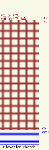
Site Elevation: 760.5 meters (2495 ft) |
| Height of Structure: 21 meters (69 feet) |
| Overall Height Above Ground: 21 meters (69 feet) |
| Overall Height Above Mean Sea Level: 781.5 meters (2564 feet) |
| Info |
| Contact Info | S & S COMMUNICATIONS
2081 WELLMAR DR.
UKIAH, CA 95482
BRUCE MASTERSON
(707) 462-9736
|
