|
|
Antenna Structure Registration 1001732 |
 |
Registration Info | Registration Number: 1001732 |
| File Number: A1153328 |
| FAA Study: 2015-AWP-8333-OE |
| FAA Issue Date: 02/26/2016 |
| Status: Constructed |
| Date Constructed: 04/01/2003 |
| NEPA: N |
Structure Info
| Structure Type: GTOWER |
| Structure Coordinates: 35-1-25.0 N 110-37-41.0 W (NAD 83) |
| Structure Coordinates: 35-01-24.9 N 110-37-38.5 W (Converted to NAD 27) |
| Structure Address: 3 Mi E |
| Structure City: Winslow, AZ |
| Structure County: Navajo County |
| Painting & Lighting Info |
FAA Circular #: 70/7460-1K |
FAA Chapters: 4, 8, 12 |
Remarks: FAA CHAPTERS 4,8,12; 70/7460-1K WITH BIRD LIGHTING DEVIATION SPECIAL CONDITION. PRIOR STUDY 2015-AWP-4475-OE |
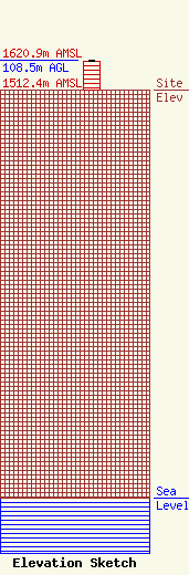
| Elevation Info |
Site Elevation: 1512.4 meters (4962 ft) |
| Height of Structure: 106.7 meters (350 feet) |
| Overall Height Above Ground: 108.5 meters (356 feet) |
| Overall Height Above Mean Sea Level: 1620.9 meters (5318 feet) |
| Owner Info | Cellco Partnership
5055 North Point Pkwy
Alpharetta, GA 30022
(770) 797-1070
Network.Regulatory@verizonwireless.com |
| Contact Info | Cellco Partnership
5055 North Point Pkwy
Alpharetta, GA 30022
Regulatory Manager
(770) 797-1070
Network.Regulatory@verizonwireless.com |
