|
|
Antenna Structure Registration 1016750 |
 |
Registration Info | Registration Number: 1016750 |
| File Number: A1232464 |
| FAA Study: 81-ACE-0944-OE |
| Status: Constructed |
| Date Constructed: 01/01/1981 |
| FAA EMI: N |
| NEPA: N |
Structure Info
| Structure Type: TOWER |
| Structure Coordinates: 41-6-47.0 N 94-21-1.0 W (NAD 83) |
| Structure Coordinates: 41-06-47.0 N 94-21-00.1 W (Converted to NAD 27) |
| Structure Address: 3 Mi N |
| Structure City: Creston, IA |
| Structure County: Union County |
| Painting & Lighting Info |
FAA Circular #: 70/7460-1H |
FAA Chapters: 4, 6, 13 |
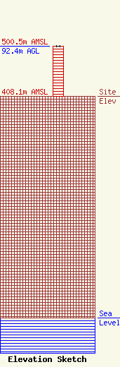
| Elevation Info |
Site Elevation: 408.1 meters (1339 ft) |
| Height of Structure: 91.4 meters (300 feet) |
| Overall Height Above Ground: 92.4 meters (303 feet) |
| Overall Height Above Mean Sea Level: 500.5 meters (1642 feet) |
| Owner Info | KN Telecommunications Inc.
1001 Lousiana Street
Houston, TX 77002
(866) 775-5785
FCC_Regulatory@kindermorgan.com |
| Contact Info | Kinder Morgan Inc.
1001 Louisiana Street
77002
Houston, TX 77002
Sean Graham
(866) 775-5785
FCC_Regulatory@kindermorgan.com |
