|
|
Antenna Structure Registration 1036459 |
 |
Registration Info | Registration Number: 1036459 |
| File Number: A1129709 |
| FAA Study: 2018-AWP-11538-OE |
| FAA Issue Date: 09/18/2018 |
| Status: Constructed |
| Date Constructed: 01/02/1966 |
Structure Info
| Structure Type: LTOWER |
| Structure Coordinates: 35-42-20.6 N 118-33-34.4 W (NAD 83) |
| Structure Coordinates: 35-42-20.8 N 118-33-31.1 W (Converted to NAD 27) |
| Structure Address: Shirley Peak, On Shirley Meadows Road (shirley Peak #89372) |
| Structure City: Wofford Heights, CA |
| Structure County: Kern County |
| Painting & Lighting Info |
FCC Paragraph(s): A1, H, 3, 11, 21, 23 |
Remarks: PRIOR STUDY 2006-AWP-5807-OE |
Remarks: Continue As Is OM&L = A MED-DUAL SYSTEM |
Remarks: PRIOR STUDY 2006-AWP-5807-OE |
Remarks: Continue As Is OM&L = A MED-DUAL SYSTEM |
| Elevation Info |
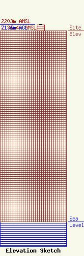
Site Elevation: 2131.4 meters (6993 ft) |
| Height of Structure: 66.7 meters (219 feet) |
| Overall Height Above Ground: 71.6 meters (235 feet) |
| Overall Height Above Mean Sea Level: 2203 meters (7228 feet) |
| Owner Info | American Towers LLC
10 Presidential Way
Woburn, MA 01801
(781) 926-4500
faa-fcc@americantower.com |
| Contact Info | American Towers LLC
10 Presidential Way
Woburn, MA 01801
(781) 926-4500
faa-fcc@americantower.com |
