|
|
Antenna Structure Registration 1065873 |
 |
Registration Info | Registration Number: 1065873 |
| File Number: A0907647 |
| FAA Study: 89-ACE-0066-OE |
| FAA Issue Date: 04/03/1989 |
| Status: Constructed |
| Date Constructed: 09/25/1989 |
| FAA EMI: N |
| NEPA: N |
Structure Info
| Structure Type: TOWER |
| Structure Coordinates: 38-31-47.0 N 96-5-10.0 W (NAD 83) |
| Structure Coordinates: 38-31-47.0 N 96-05-09.0 W (Converted to NAD 27) |
| Structure Address: .8 Miles Northeast Of Rts 99 And 17 |
| Structure City: Reading, KS |
| Structure County: Lyon County |
| Painting & Lighting Info |
FAA Circular #: 70/7460-1G |
FAA Chapters: 3, 4, 5, 9 |
| Elevation Info |
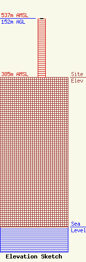
Site Elevation: 385 meters (1263 ft) |
| Height of Structure: 151 meters (495 feet) |
| Overall Height Above Ground: 152 meters (499 feet) |
| Overall Height Above Mean Sea Level: 537 meters (1762 feet) |
| Owner Info | C&C CONSULTING, INC.
2001 Morningside Drive
EMPORIA, KS 66801-5434
(620) 343-7057
edwardalipson@gmail.com |
| Contact Info | C & C Consulting, Inc.
2001 Morningside Drive
Emporia, KS 66801-5434
Ed Lipson
(620) 366-0826
edwardalipson@gmail.com |
