|
|
Antenna Structure Registration 1000400 |
 |
Registration Info | Registration Number: 1000400 |
| File Number: A1344592 |
| FAA Study: 78-RM-68-OE |
| FAA Issue Date: 04/12/1978 |
| Status: Constructed |
| Date Constructed: 08/10/1978 |
| FAA EMI: N |
| NEPA: N |
Structure Info
| Structure Type: TOWER |
| Structure Coordinates: 46-52-56.0 N 113-59-11.0 W (NAD 83) |
| Structure Coordinates: 46-52-56.3 N 113-59-07.6 W (Converted to NAD 27) |
| Structure Address: Waterworks Hill .8 Km Ne Of Downtown |
| Structure City: Missoula, MT |
| Structure County: Missoula County |
| Painting & Lighting Info |
FCC Paragraph(s): 1, 3, 11, 21 |
Remarks: RED LIGHTS/PAINT |
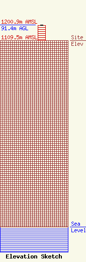
| Elevation Info |
Site Elevation: 1109.5 meters (3640 ft) |
| Height of Structure: 89.9 meters (295 feet) |
| Overall Height Above Ground: 91.4 meters (300 feet) |
| Overall Height Above Mean Sea Level: 1200.9 meters (3940 feet) |
| Owner Info | Vertical Bridge CCR, LLC
22 W Atlantic Avenue
Delray Beach, FL 33444
(561) 406-4015
fcc-faa@verticalbridge.com |
| Contact Info | Vertical Bridge CCR, LLC
22 W Atlantic Avenue
Delray Beach, FL 33444
Richard Hickey
(561) 406-4015
fcc-faa@verticalbridge.com |
