|
|
Antenna Structure Registration 1032208 |
 |
Registration Info | Registration Number: 1032208 |
| File Number: A1058209 |
| FAA Study: 01-ACE-2236-OE |
| FAA Issue Date: 09/27/2001 |
| Status: Constructed |
| Date Constructed: 12/19/1994 |
| FAA EMI: N |
| NEPA: N |
Structure Info
| Structure Type: TOWER |
| Structure Coordinates: 37-23-7.4 N 95-14-6.9 W (NAD 83) |
| Structure Coordinates: 37-23-07.2 N 95-14-06.0 W (Converted to NAD 27) |
| Structure Address: 4.8 Km North |
| Structure City: Parsons, KS |
| Structure County: Neosho County |
| Painting & Lighting Info |
FCC Paragraph(s): A2, H, 3, 4, 13, 21, 23 |
Remarks: OM&L TO REMAIN MED DUAL SYSTEM AS PER PRIOR STUDY 01-ACE-2028-OE |
Remarks: Removed expiration date from determination. Scenario 1./jjs/case#635066 |
Remarks: OM&L TO REMAIN MED DUAL SYSTEM AS PER PRIOR STUDY 01-ACE-2028-OE |
Remarks: Removed expiration date from determination. Scenario 1./jjs/case#635066 |
| Elevation Info |
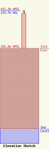
Site Elevation: 281.6 meters (924 ft) |
| Height of Structure: 121.9 meters (400 feet) |
| Overall Height Above Ground: 130.7 meters (429 feet) |
| Overall Height Above Mean Sea Level: 412.3 meters (1353 feet) |
| Owner Info | American Towers LLC
10 Presidential Way
Woburn, MA 01801
(781) 926-4500
faa-fcc@americantower.com |
| Contact Info | American Towers, LLC
10 Presidential Way
Woburn, MA 01801
(781) 926-4500
faa-fcc@americantower.com |
