|
|
Antenna Structure Registration 1032508 |
 |
Registration Info | Registration Number: 1032508 |
| File Number: A0314190 |
| FAA Study: 87-ACE-0505-OE |
| FAA Issue Date: 04/08/1988 |
| Status: Constructed |
| Date Constructed: 12/01/1963 |
| FAA EMI: N |
| NEPA: N |
Structure Info
| Structure Type: TOWER |
| Structure Coordinates: 39-15-41.0 N 95-39-21.0 W (NAD 83) |
| Structure Coordinates: 39-15-41.0 N 95-39-20.1 W (Converted to NAD 27) |
| Structure Address: 4.2 Km Ene |
| Structure City: Hoyt, KS |
| Structure County: Jackson County |
| Painting & Lighting Info |
FCC Paragraph(s): A2, H |
Remarks: MEDIUM INTENSITY WHITE LIGHTS |
| Elevation Info |
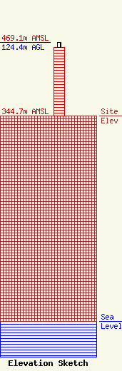
Site Elevation: 344.7 meters (1131 ft) |
| Height of Structure: 115.2 meters (378 feet) |
| Overall Height Above Ground: 124.4 meters (408 feet) |
| Overall Height Above Mean Sea Level: 469.1 meters (1539 feet) |
| Owner Info | Heartland Tower Inc.
PO Box 5307
Topeka, KS 66605
(785) 266-3999
fcc@heartlandtower.com |
| Info |
