|
|
Antenna Structure Registration 1202683 |
 |
Registration Info | Registration Number: 1202683 |
| File Number: A0143211 |
| FAA Study: 96-AGL-0520-OE |
| FAA Issue Date: 04/18/1996 |
| Status: Constructed |
| Date Constructed: 10/17/1996 |
| FAA EMI: N |
| NEPA: N |
Structure Info
| Structure Type: TOWER |
| Structure Coordinates: 44-25-12.9 N 100-20-49.4 W (NAD 83) |
| Structure Coordinates: 44-25-13.0 N 100-20-47.9 W (Converted to NAD 27) |
| Structure Address: Pierre, South Dakota |
| Structure City: Pierre, SD |
| Structure County: Hughes County |
| Painting & Lighting Info |
FAA Chapters: NONE |
| Elevation Info |
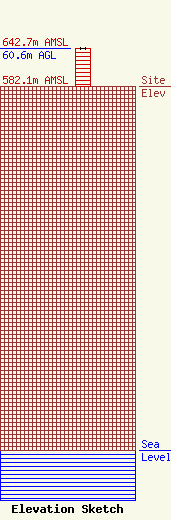
Site Elevation: 582.1 meters (1910 ft) |
| Height of Structure: 60.6 meters (199 feet) |
| Overall Height Above Ground: 60.6 meters (199 feet) |
| Overall Height Above Mean Sea Level: 642.7 meters (2109 feet) |
| Owner Info | Pierre Radio Paging & Telephone Inc
99
Pierre, SD 57501-0099
(605) 224-2848
|
| Contact Info | Pierre Radio Paging & Telephone, Inc
99
Pierre, SD 57501
Eldon Lindquist
(605) 224-2848
|
