|
|
Antenna Structure Registration 1201223 |
 |
Registration Info | Registration Number: 1201223 |
| File Number: A1222255 |
| FAA Study: 2022-AWP-13313-OE |
| FAA Issue Date: 09/09/2022 |
| Status: Constructed |
| Date Constructed: 05/14/2009 |
| NEPA: N |
Structure Info
| Structure Type: GTOWER |
| Structure Coordinates: 19-35-20.5 N 155-7-26.1 W (NAD 83) |
| Structure Coordinates: 19-35-31.4 N 155-07-36.1 W (Converted to NAD 27) |
| Structure Address: 17-4940 South Rd (303431 / Mountain View Hi 6) |
| Structure City: Mountain View, HI |
| Structure County: Hawaii County |
| Painting & Lighting Info |
FAA Chapters: NONE |
Remarks: PRIOR STUDY 2013-AWP-2001-OE |
| Elevation Info |
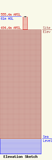
Site Elevation: 494.4 meters (1622 ft) |
| Height of Structure: 57.9 meters (190 feet) |
| Overall Height Above Ground: 61 meters (200 feet) |
| Overall Height Above Mean Sea Level: 555.4 meters (1822 feet) |
| Owner Info | SpectraSite Communications, LLC. through American Towers, LLC.
10 Presidential Way
Woburn, MA 01801
(781) 926-4500
faa-fcc@americantower.com |
| Contact Info | SpectraSite Communications, LLC. through American Towers, LLC.
10 Presidential Way
Woburn, MA 01801
(781) 926-4500
faa-fcc@americantower.com |
