|
|
Antenna Structure Registration 1040699 |
 |
Registration Info | Registration Number: 1040699 |
| File Number: A1283078 |
| FAA Study: 2022-ACE-7172-OE |
| FAA Issue Date: 12/14/2022 |
| Status: Constructed |
| Date Constructed: 10/01/2023 |
| NEPA: N |
Structure Info
| Structure Type: LTOWER |
| Structure Coordinates: 41-26-21.6 N 97-23-48.1 W (NAD 83) |
| Structure Coordinates: 41-26-21.6 N 97-23-46.9 W (Converted to NAD 27) |
| Structure Address: Sw1/4 Of Se1/4 Of Sect 14 Twp17n Range 1w |
| Structure City: Columbus, NE |
| Structure County: Platte County |
| Painting & Lighting Info |
FCC Paragraph(s): A1, H, 3, 11, 21, 23 |
Remarks: PRIOR STUDY 1989-ACE-665-OE |
Remarks: Continue As Is OM&L = A MED-DUAL SYSTEM |
Remarks: PRIOR STUDY 1989-ACE-665-OE |
Remarks: Continue As Is OM&L = A MED-DUAL SYSTEM |
| Elevation Info |
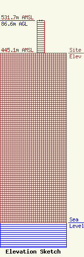
Site Elevation: 445.1 meters (1460 ft) |
| Height of Structure: 86.6 meters (284 feet) |
| Overall Height Above Ground: 86.6 meters (284 feet) |
| Overall Height Above Mean Sea Level: 531.7 meters (1744 feet) |
| Owner Info | PLATTE, COUNTY OF
2610 14TH STREET
COLUMBUS, NE 68601
(402) 564-1206
thofbauer@plattecounty.ne.gov |
| Contact Info | PLATTE, COUNTY OF
2610 14TH STREET
COLUMBUS, NE 68601
Tim Hofbauer
(402) 564-1206
thofbauer@plattecounty.ne.gov |
