|
|
Antenna Structure Registration 1027927 |
 |
Registration Info | Registration Number: 1027927 |
| File Number: A0728095 |
| FAA Study: 2010-ANM-839-OE |
| FAA Issue Date: 04/27/2010 |
| Status: Constructed |
| Date Constructed: 05/16/2011 |
| FAA EMI: N |
| NEPA: N |
Structure Info
| Structure Type: TOWER |
| Structure Coordinates: 43-21-15.0 N 124-14-34.0 W (NAD 83) |
| Structure Coordinates: 43-21-15.6 N 124-14-29.6 W (Converted to NAD 27) |
| Structure Address: Blossom Hill |
| Structure City: Coos Bay, OR |
| Structure County: Coos County |
| Painting & Lighting Info |
FAA Chapters: NONE |
Remarks: PRIOR STUDY 1997-ANM-1142-OE |
| Elevation Info |
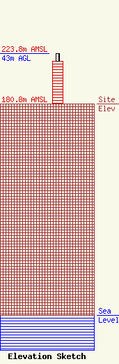
Site Elevation: 180.8 meters (593 ft) |
| Height of Structure: 36.6 meters (120 feet) |
| Overall Height Above Ground: 43 meters (141 feet) |
| Overall Height Above Mean Sea Level: 223.8 meters (734 feet) |
| Owner Info | PRIME SITE INC.
287 SOUTH 7TH STREET
COOS BAY, OR 97420
(541) 267-7190
|
