|
|
Antenna Structure Registration 1027634 |
 |
Registration Info | Registration Number: 1027634 |
| File Number: A0842860 |
| FAA Study: 94-ANM-0809-OE |
| FAA Issue Date: 10/11/1994 |
| Status: Constructed |
| Date Constructed: 05/30/2013 |
| FAA EMI: N |
| NEPA: N |
Structure Info
| Structure Type: TOWER |
| Structure Coordinates: 38-2-14.0 N 102-35-53.0 W (NAD 83) |
| Structure Coordinates: 38-02-14.0 N 102-35-51.3 W (Converted to NAD 27) |
| Structure Address: 2.5 Mi S On Hwy 287 1 Mi E |
| Structure City: Lamar, CO |
| Structure County: Prowers County |
| Painting & Lighting Info |
FAA Circular #: 70/7460-1H |
FAA Chapters: 3, 4, 5, 13 |
| Elevation Info |
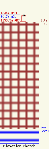
Site Elevation: 1153.3 meters (3784 ft) |
| Height of Structure: 73.2 meters (240 feet) |
| Overall Height Above Ground: 80.7 meters (265 feet) |
| Overall Height Above Mean Sea Level: 1234 meters (4049 feet) |
| Owner Info | Big Towers, LLC
308
Lamar, CO 81052
(719) 336-9066
coloradomobile@cminet.net |
