|
|
Antenna Structure Registration 1019013 |
 |
Registration Info | Registration Number: 1019013 |
| File Number: A1344587 |
| FAA Study: 2018-ANM-1639-OE |
| FAA Issue Date: 06/12/2018 |
| Status: Constructed |
| Date Constructed: 03/15/1997 |
| NEPA: N |
Structure Info
| Structure Type: GTOWER |
| Structure Coordinates: 47-32-19.5 N 111-15-42.8 W (NAD 83) |
| Structure Coordinates: 47-32-19.7 N 111-15-39.9 W (Converted to NAD 27) |
| Structure Address: 185 Black Eagle Rd. / Us-mt-5014 |
| Structure City: Black Eagle, MT |
| Structure County: Cascade County |
| Painting & Lighting Info |
FAA Circular #: 70/7460-1L |
FAA Chapters: 4, 8, 12 |
Remarks: PRIOR STUDY 1998-ANM-275-OE |
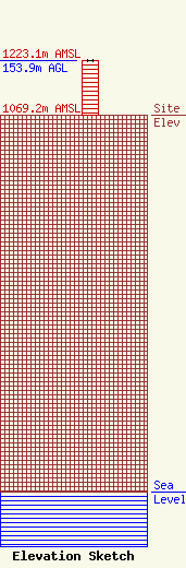
| Elevation Info |
Site Elevation: 1069.2 meters (3508 ft) |
| Height of Structure: 153.9 meters (505 feet) |
| Overall Height Above Ground: 153.9 meters (505 feet) |
| Overall Height Above Mean Sea Level: 1223.1 meters (4013 feet) |
| Owner Info | Vertical Bridge CCR, LLC
22 W Atlantic Avenue
Delray Beach, FL 33444
(561) 406-4015
fcc-faa@verticalbridge.com |
| Contact Info | Vertical Bridge CCR, LLC
22 W Atlantic Avenue
Delray Beach, FL 33444
Richard Hickey
(561) 406-4015
fcc-faa@verticalbridge.com |
