|
|
Antenna Structure Registration 1234773 |
 |
Registration Info | Registration Number: 1234773 |
| File Number: A1181795 |
| FAA Study: 2011-ANM-361-OE |
| FAA Issue Date: 02/17/2011 |
| Status: Constructed |
| Date Constructed: 06/01/2002 |
| FAA EMI: N |
| NEPA: N |
Structure Info
| Structure Type: TOWER |
| Structure Coordinates: 45-11-0.6 N 113-52-17.1 W (NAD 83) |
| Structure Coordinates: 45-11-00.9 N 113-52-13.9 W (Converted to NAD 27) |
| Structure Address: 152 Lemhi Rd. - 83467 |
| Structure City: Salmon, ID |
| Structure County: Lemhi County |
| Painting & Lighting Info |
FAA Circular #: 70/7460-1K |
FAA Chapters: 4, 8, 12 |
Remarks: PRIOR STUDY 2002-ANM-783-OE |
| Elevation Info |
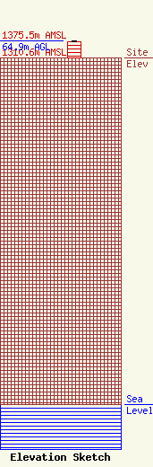
Site Elevation: 1310.6 meters (4300 ft) |
| Height of Structure: 61 meters (200 feet) |
| Overall Height Above Ground: 64.9 meters (213 feet) |
| Overall Height Above Mean Sea Level: 1375.5 meters (4513 feet) |
| Owner Info | American Towers LLC
10 Presidential Way
Woburn, MA 01801
(781) 926-4500
faa-fcc@americantower.com |
| Contact Info | American Towers LLC
10 Presidential Way
Woburn, MA 01801
(781) 926-4500
faa-fcc@americantower.com |
