|
|
Antenna Structure Registration 1063871 |
 |
Registration Info | Registration Number: 1063871 |
| File Number: A0074502 |
| Status: Terminated |
| Date Constructed: 01/01/1980 |
| NEPA: N |
Structure Info
| Structure Type: TOWER |
| Structure Coordinates: 41-21-9.0 N 110-54-29.0 W (NAD 83) |
| Structure Coordinates: 41-21-09.2 N 110-54-26.3 W (Converted to NAD 27) |
| Structure Address: Medicine Butte 6.5 Mi Ne |
| Structure City: Evanston, WY |
| Structure County: Uinta County |
| Painting & Lighting Info |
FCC Paragraph(s): None |
| Elevation Info |
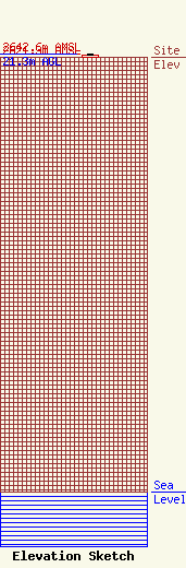
Site Elevation: 2621.3 meters (8600 ft) |
| Height of Structure: 15.2 meters (50 feet) |
| Overall Height Above Ground: 21.3 meters (70 feet) |
| Overall Height Above Mean Sea Level: 2642.6 meters (8670 feet) |
| Owner Info | QUESTAR INFOCOMM INC
180E 100S
SALT LAKE CITY, UT 84145-0433
(801) 324-1941
JONH@QSTR.COM |
