|
|
Antenna Structure Registration 1019388 |
 |
Registration Info | Registration Number: 1019388 |
| File Number: A0597484 |
| FAA Study: 97-AWP-0538-OE |
| FAA Issue Date: 03/25/1997 |
| Status: Constructed |
| Date Constructed: 07/11/1969 |
| FAA EMI: N |
| NEPA: N |
Structure Info
| Structure Type: TOWER |
| Structure Coordinates: 22-0-6.0 N 159-21-28.0 W (NAD 83) |
| Structure Coordinates: 22-00-17.3 N 159-21-38.1 W (Converted to NAD 27) |
| Structure Address: .5 Mi Nw |
| Structure City: Hanamaulu, HI |
| Structure County: Kauai County |
| Painting & Lighting Info |
FAA Circular #: 70/7460-1J |
FAA Chapters: 3, 4, 5, 13 |
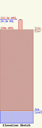
| Elevation Info |
Site Elevation: 198 meters (650 ft) |
| Height of Structure: 24 meters (79 feet) |
| Overall Height Above Ground: 24.3 meters (80 feet) |
| Overall Height Above Mean Sea Level: 222.3 meters (729 feet) |
| Owner Info | Hawaiian Telcom, Inc.
2200
Honolulu, HI 96841
(808) 546-1554
sean.oliveira@hawaiiantel.com |
