|
|
Antenna Structure Registration 1014770 |
 |
Registration Info | Registration Number: 1014770 |
| File Number: A1354723 |
| FAA Study: 2011-ANM-1639-OE |
| FAA Issue Date: 08/23/2011 |
| Status: Constructed |
| Date Constructed: 06/22/2010 |
| FAA EMI: N |
| NEPA: N |
Structure Info
| Structure Type: TOWER |
| Structure Coordinates: 48-10-32.5 N 114-21-1.4 W (NAD 83) |
| Structure Coordinates: 48-10-32.7 N 114-20-57.9 W (Converted to NAD 27) |
| Structure Address: Lone Pine State Park |
| Structure City: Kalispell, MT |
| Structure County: Flathead County |
| Painting & Lighting Info |
FAA Circular #: 70/7460-1K |
FAA Chapters: 4, 5, 12 |
Remarks: OM&L to remain the same as prior study = RED LIGHTS |
Remarks: PRIOR STUDY 2001-ANM-3033-OE |
Remarks: OM&L to remain the same as prior study = RED LIGHTS |
Remarks: PRIOR STUDY 2001-ANM-3033-OE |
| Elevation Info |
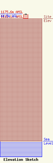
Site Elevation: 1131.1 meters (3711 ft) |
| Height of Structure: 40.5 meters (133 feet) |
| Overall Height Above Ground: 44.5 meters (146 feet) |
| Overall Height Above Mean Sea Level: 1175.6 meters (3857 feet) |
| Owner Info | CCATT LLC
2000 Corporate Drive
Canonsburg, PA 15317
(724) 416-2000
Regulatory.Department@crowncastle.com |
| Contact Info | Crown Castle
2000 Corporate Drive
Canonsburg, PA 15317
Tom Anderson
(724) 743-6330
Tom.Anderson@crowncastle.com |
