|
|
Antenna Structure Registration 1012284 |
 |
Registration Info | Registration Number: 1012284 |
| File Number: A0864873 |
| FAA Study: 94-AWP-984-OE |
| Status: Constructed |
| Date Constructed: 06/01/1996 |
| FAA EMI: N |
| NEPA: N |
Structure Info
| Structure Type: TOWER |
| Structure Coordinates: 37-31-59.0 N 120-1-40.0 W (NAD 83) |
| Structure Coordinates: 37-31-59.2 N 120-01-36.4 W (Converted to NAD 27) |
| Structure Address: 6273 Morrissey Rd |
| Structure City: Mariposa, CA |
| Structure County: Mariposa County |
| Painting & Lighting Info |
FAA Circular #: 70/7460-1H |
FAA Chapters: 3, 4, 5, 13 |
| Elevation Info |
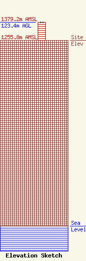
Site Elevation: 1255.8 meters (4120 ft) |
| Height of Structure: 123.4 meters (405 feet) |
| Overall Height Above Ground: 123.4 meters (405 feet) |
| Overall Height Above Mean Sea Level: 1379.2 meters (4525 feet) |
| Owner Info | Hughes Communications
1886 Poppy Hills Ct.
Merced, CA 95340
(209) 761-7574
rschwaninger@sa-lawyers.net |
| Contact Info | Schwaninger Law, P.C.
6715 Little River Tnpk, Suite 204
Annandale, VA 22003
Richard Hanno
(703) 256-0637
rschwaninger@sa-lawyers.net |
