|
|
Antenna Structure Registration 1274267 |
 |
Registration Info | Registration Number: 1274267 |
| File Number: A0729056 |
| FAA Study: 2010-ASW-2059-OE |
| FAA Issue Date: 04/27/2010 |
| Status: Constructed |
| Date Constructed: 05/25/2011 |
| FAA EMI: N |
| NEPA: N |
Structure Info
| Structure Type: TOWER |
| Structure Coordinates: 34-2-12.3 N 96-25-37.8 W (NAD 83) |
| Structure Coordinates: 34-02-12.0 N 96-25-36.8 W (Converted to NAD 27) |
| Structure Address: 3.64 Miles @ 314°true From Center Of Durant, Ok |
| Structure City: Durant, OK |
| Structure County: Bryan County |
| Painting & Lighting Info |
FAA Circular #: 70/7460-1K |
FAA Chapters: 3, 4, 5, 12 |
Remarks: Removed expiration date from determination. Scenario 1./jjs/case#635066 |
| Elevation Info |
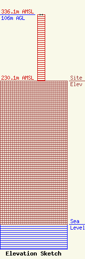
Site Elevation: 230.1 meters (755 ft) |
| Height of Structure: 106 meters (348 feet) |
| Overall Height Above Ground: 106 meters (348 feet) |
| Overall Height Above Mean Sea Level: 336.1 meters (1103 feet) |
| Owner Info | Texoma Broadcasting, Inc.
1418 North 1st Street
Durant, OK 74702
Todd Tidwell
(580) 924-8823
toddt@netcommander.com |
| Contact Info | Texoma Broadcasting, Inc.
1418 North 1st Street
Durant, OK 74702
Todd Tidwell
(580) 924-8823
toddt@netcommander.com |
