|
|
Antenna Structure Registration 1023172 |
 |
Registration Info | Registration Number: 1023172 |
| File Number: A1087512 |
| FAA Study: 2016-AWP-8850-OE |
| FAA Issue Date: 11/21/2016 |
| Status: Constructed |
| Date Constructed: 01/01/1995 |
| NEPA: N |
Structure Info
| Structure Type: GTOWER |
| Structure Coordinates: 36-17-42.2 N 115-16-53.5 W (NAD 83) |
| Structure Coordinates: 36-17-42.3 N 115-16-50.5 W (Converted to NAD 27) |
| Structure Address: 7375 Tule Springs Rd. |
| Structure City: Las Vegas, NV |
| Structure County: Clark County |
| Painting & Lighting Info |
FAA Circular #: 70/7460-1H |
FAA Chapters: 3, 4, 5, 13 |
Remarks: OM&L to remain the same as prior study = PAINT/RED LIGHTS |
Remarks: PRIOR STUDY 2016-AWP-7568-OE |
Remarks: OM&L to remain the same as prior study = PAINT/RED LIGHTS |
Remarks: PRIOR STUDY 2016-AWP-7568-OE |
| Elevation Info |
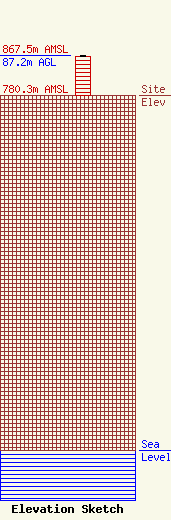
Site Elevation: 780.3 meters (2560 ft) |
| Height of Structure: 86.3 meters (283 feet) |
| Overall Height Above Ground: 87.2 meters (286 feet) |
| Overall Height Above Mean Sea Level: 867.5 meters (2846 feet) |
| Owner Info | CCATT LLC
2000 Corporate Drive
Canonsburg, PA 15317
(724) 416-2000
Regulatory.Department@Crowncastle.com |
| Contact Info | Crown Castle
2000 Corporate Drive
Canonsburg, PA 15317
Don Snyder
(724) 416-2470
Don.Snyder@crowncastle.com |
