|
|
Antenna Structure Registration 1241217 |
 |
Registration Info | Registration Number: 1241217 |
| File Number: A0357416 |
| FAA Study: 2003-AAL-609-OE |
| FAA Issue Date: 09/25/2003 |
| Status: Constructed |
| Date Constructed: 10/07/2003 |
| FAA EMI: N |
| NEPA: N |
Structure Info
| Structure Type: TOWER |
| Structure Coordinates: 57-47-20.0 N 152-26-3.5 W (NAD 83) |
| Structure Coordinates: 57-47-22.7 N 152-25-55.6 W (Converted to NAD 27) |
| Structure Address: Comm Site 2 Pillar Mtn Road |
| Structure City: Kodiak, AK |
| Structure County: Kodiak Island Borough |
| Painting & Lighting Info |
FAA Chapters: NONE |
| Elevation Info |
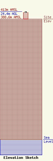
Site Elevation: 388.6 meters (1275 ft) |
| Height of Structure: 21.3 meters (70 feet) |
| Overall Height Above Ground: 24.4 meters (80 feet) |
| Overall Height Above Mean Sea Level: 413 meters (1355 feet) |
| Owner Info | AKSALA ELECTRONICS INC
1623 MILL BAY RD
KODIAK, AK 99615
(907) 486-4700
KARES@PTIALASKA.NET |
