|
|
Antenna Structure Registration 1299621 |
 |
Registration Info | Registration Number: 1299621 |
| File Number: A1049550 |
| FAA Study: 2003-ACE-942-OE |
| FAA Issue Date: 05/08/2003 |
| Status: Constructed |
| Date Constructed: 09/12/2016 |
Structure Info
| Structure Type: GTOWER |
| Structure Coordinates: 39-46-21.0 N 99-18-29.0 W (NAD 83) |
| Structure Coordinates: 39-46-21.0 N 99-18-27.7 W (Converted to NAD 27) |
| Structure Address: 1.5 Miles Ne Phillipsburg, Ks 67661 |
| Structure City: Phillipsburg, KS |
| Structure County: Phillips County |
| Painting & Lighting Info |
FAA Circular #: 70/7460-1K |
FAA Chapters: 4, 8, 12 |
| Elevation Info |
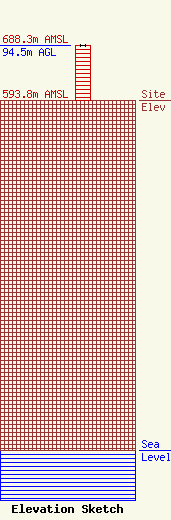
Site Elevation: 593.8 meters (1948 ft) |
| Height of Structure: 94.5 meters (310 feet) |
| Overall Height Above Ground: 94.5 meters (310 feet) |
| Overall Height Above Mean Sea Level: 688.3 meters (2258 feet) |
| Owner Info | Midwest Energy, Inc.
1330 Canterbury Dr.
Hays, KS 67601
(785) 650-2525
tflax@mwenergy.com |
| Contact Info | Midwest Energy, Inc.
1330 Canterbury Dr.
Hays, KS 67601
Timothy Flax
(785) 650-2525
tflax@mwenergy.com |
