|
|
Antenna Structure Registration 1217299 |
 |
Registration Info | Registration Number: 1217299 |
| File Number: A1204604 |
| FAA Study: 00-ANM-1199-OE |
| FAA Issue Date: 08/03/2000 |
| Status: Constructed |
| Date Constructed: 02/20/2014 |
| FAA EMI: N |
| NEPA: N |
Structure Info
| Structure Type: TOWER |
| Structure Coordinates: 41-46-15.8 N 107-14-17.6 W (NAD 83) |
| Structure Coordinates: 41-46-15.9 N 107-14-15.4 W (Converted to NAD 27) |
| Structure Address: .5 Miles South Of I-25 On Rawlins Hill |
| Structure City: Rawlins, WY |
| Structure County: Carbon County |
| Painting & Lighting Info |
FCC Paragraph(s): 1, 3, 11, 21 |
Remarks: CONTINUE OM&L PAINT RED LIGHTS |
| Elevation Info |
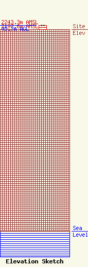
Site Elevation: 2197.6 meters (7210 ft) |
| Height of Structure: 45.7 meters (150 feet) |
| Overall Height Above Ground: 45.7 meters (150 feet) |
| Overall Height Above Mean Sea Level: 2243.3 meters (7360 feet) |
| Owner Info | K2 Towers III, LLC
57 E Washington St
Chagrin Falls, OH 44022
(440) 528-0333
rlepene@peppertreecapital.com |
| Contact Info | K2 Towers III, LLC
57 E Washington St
Chagrin Falls, OH 44022
Greg Thompson
(440) 528-0333
gthompson@k2towers.com |
