|
|
Antenna Structure Registration 1026519 |
 |
Registration Info | Registration Number: 1026519 |
| File Number: A0693926 |
| FAA Study: 97-ACE-1840-OE |
| FAA Issue Date: 02/20/1998 |
| Status: Constructed |
| Date Constructed: 01/01/1964 |
| FAA EMI: N |
| NEPA: N |
Structure Info
| Structure Type: TOWER |
| Structure Coordinates: 42-1-56.0 N 97-22-8.0 W (NAD 83) |
| Structure Coordinates: 42-01-56.0 N 97-22-06.8 W (Converted to NAD 27) |
| Structure Address: Approx .75 Mi E |
| Structure City: Norfolk, NE |
| Structure County: Madison County |
| Painting & Lighting Info |
FAA Circular #: 70/7460-1J |
FAA Chapters: 3, 4, 5, 13 |
| Elevation Info |
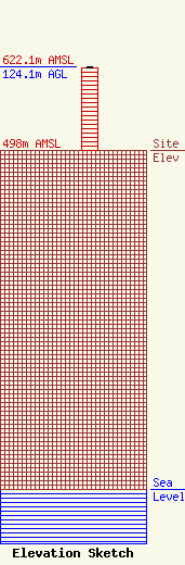
Site Elevation: 498 meters (1634 ft) |
| Height of Structure: 121.9 meters (400 feet) |
| Overall Height Above Ground: 124.1 meters (407 feet) |
| Overall Height Above Mean Sea Level: 622.1 meters (2041 feet) |
| Owner Info | Tommark Properties
2404 Taylor Avenue
Norfolk, NE 68701
(402) 841-2337
tom@telebeep.com |
