|
|
Antenna Structure Registration 1045703 |
 |
Registration Info | Registration Number: 1045703 |
| File Number: A1217686 |
| FAA Study: 2008-ACE-3414-OE |
| FAA Issue Date: 10/04/2008 |
| Status: Constructed |
| Date Constructed: 01/01/1990 |
| FAA EMI: N |
| NEPA: N |
Structure Info
| Structure Type: TOWER |
| Structure Coordinates: 37-51-23.9 N 94-22-48.0 W (NAD 83) |
| Structure Coordinates: 37-51-23.8 N 94-22-47.2 W (Converted to NAD 27) |
| Structure Address: 15649 S. 1400 Rd., Nevada, Mo 64772 |
| Structure City: Nevada, MO |
| Structure County: Vernon County |
| Painting & Lighting Info |
FAA Chapters: NONE |
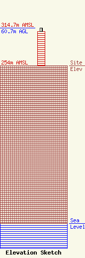
| Elevation Info |
Site Elevation: 254 meters (833 ft) |
| Height of Structure: 55.2 meters (181 feet) |
| Overall Height Above Ground: 60.7 meters (199 feet) |
| Overall Height Above Mean Sea Level: 314.7 meters (1032 feet) |
| Owner Info | Evergy Missouri West, Inc.
1200 Main Street
Kansas City, MO 64105
(785) 575-1050
Worthy.Stutler@evergy.com |
| Contact Info | Womble Bond Dickinson (US) LLP
2001 K Street, NW
Washington, DC 20006
Marjorie Spivak
(202) 857-4538
marjorie.spivak@wbd-us.com |
