|
|
Antenna Structure Registration 1023009 |
 |
Registration Info | Registration Number: 1023009 |
| File Number: A1257526 |
| FAA Study: 97-ACE-0553-OE |
| FAA Issue Date: 05/08/1997 |
| Status: Constructed |
| Date Constructed: 10/01/1987 |
| NEPA: N |
Structure Info
| Structure Type: TOWER |
| Structure Coordinates: 42-1-21.0 N 92-59-58.0 W (NAD 83) |
| Structure Coordinates: 42-01-21.0 N 92-59-57.3 W (Converted to NAD 27) |
| Structure Address: 2280 Marsh Ave |
| Structure City: Marshalltown, IA |
| Structure County: Marshall County |
| Painting & Lighting Info |
FAA Circular #: 70/7460-1J |
FAA Chapters: 3, 4, 5, 13 |
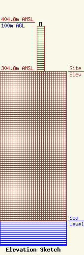
| Elevation Info |
Site Elevation: 304.8 meters (1000 ft) |
| Height of Structure: 92 meters (302 feet) |
| Overall Height Above Ground: 100 meters (328 feet) |
| Overall Height Above Mean Sea Level: 404.8 meters (1328 feet) |
| Owner Info | Trending Media, Inc.
123 West Main St
Marshalltown, IA 50158
(641) 753-3361
todd@trendingm.com |
| Contact Info | Fletcher, Heald & Hildreth, PLC
1300 17th St N
Arlington, VA 22209
Sara Hinkle
(703) 812-0415
hinkle@fhhlaw.com |
