|
|
Antenna Structure Registration 1053690 |
 |
Registration Info | Registration Number: 1053690 |
| File Number: A0063128 |
| Status: Constructed |
| Date Constructed: 01/01/1968 |
| NEPA: N |
Structure Info
| Structure Type: TOWER |
| Structure Coordinates: 29-43-51.0 N 98-7-13.0 W (NAD 83) |
| Structure Coordinates: 29-43-50.2 N 98-07-12.0 W (Converted to NAD 27) |
| Structure Address: 1540 Loop 337 N |
| Structure City: New Braunfels, TX |
| Structure County: Comal County |
| Painting & Lighting Info |
FCC Paragraph(s): 1, 3, 12, 21 |
| Elevation Info |
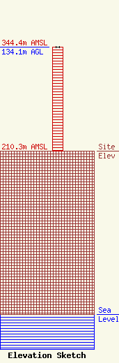
Site Elevation: 210.3 meters (690 ft) |
| Height of Structure: 134.1 meters (440 feet) |
| Overall Height Above Ground: 134.1 meters (440 feet) |
| Overall Height Above Mean Sea Level: 344.4 meters (1130 feet) |
| Owner Info | NEW BRAUNFELS COMMUNICATIONS DBA = KNBT RADIO
1540 LOOP 337 N
NEW BRAUNFELS, TX 78130
(830) 625-7311
|
