|
|
Antenna Structure Registration 1297722 |
 |
Registration Info | Registration Number: 1297722 |
| File Number: A1033717 |
| FAA Study: 2016-ASW-1816-OE |
| FAA Issue Date: 04/29/2016 |
| Status: Constructed |
| Date Constructed: 04/12/2016 |
Structure Info
| Structure Type: GTOWER |
| Structure Coordinates: 35-27-1.0 N 99-27-38.1 W (NAD 83) |
| Structure Coordinates: 35-27-00.8 N 99-27-36.8 W (Converted to NAD 27) |
| Structure Address: 1975 E. 1080 Rd. (#4475) |
| Structure City: Elk City, OK |
| Structure County: Beckham County |
| Painting & Lighting Info |
FAA Circular #: 70/7460-1L |
FAA Chapters: 4, 8, 12 |
Remarks: Removed expiration date from determination. Scenario 1./jjs/case#635066 |
Remarks: PRIOR STUDY 2004-ASW-4879-OE |
Remarks: Removed expiration date from determination. Scenario 1./jjs/case#635066 |
Remarks: PRIOR STUDY 2004-ASW-4879-OE |
| Elevation Info |
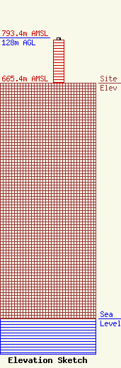
Site Elevation: 665.4 meters (2183 ft) |
| Height of Structure: 121.9 meters (400 feet) |
| Overall Height Above Ground: 128 meters (420 feet) |
| Overall Height Above Mean Sea Level: 793.4 meters (2603 feet) |
| Owner Info | American Towers LLC
10 Presidential Way
Woburn, MA 01801
(678) 564-3236
faa-fcc@americantower.com |
| Contact Info | American Towers, LLC
10 Presidential Way
Woburn, MA 01801
(678) 564-3236
faa-fcc@americantower.com |
