|
|
Antenna Structure Registration 1218040 |
 |
Registration Info | Registration Number: 1218040 |
| File Number: A1208319 |
| FAA Study: 2021-ASW-11359-OE |
| FAA Issue Date: 12/07/2021 |
| Status: Constructed |
| Date Constructed: 08/29/2014 |
| NEPA: N |
Structure Info
| Structure Type: GTOWER |
| Structure Coordinates: 34-26-24.2 N 103-12-31.8 W (NAD 83) |
| Structure Coordinates: 34-26-23.9 N 103-12-30.0 W (Converted to NAD 27) |
| Structure Address: 1074 State Route 245 (#209129) |
| Structure City: Clovis, NM |
| Structure County: Curry County |
| Painting & Lighting Info |
FAA Circular #: 70/7460-1M |
FAA Chapters: 4, 8, 15 |
Remarks: PRIOR STUDY 2014-ASW-3513-OE |
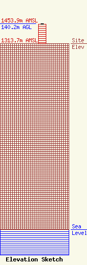
| Elevation Info |
Site Elevation: 1313.7 meters (4310 ft) |
| Height of Structure: 134.1 meters (440 feet) |
| Overall Height Above Ground: 140.2 meters (460 feet) |
| Overall Height Above Mean Sea Level: 1453.9 meters (4770 feet) |
| Owner Info | American Towers LLC
10 Presidential Way
Woburn, MA 01801
(781) 926-4500
faa-fcc@americantower.com |
| Contact Info | American Towers LLC
10 Presidential Way
Woburn, MA 01801
(781) 926-4500
faa-fcc@americantower.com |
