|
|
Antenna Structure Registration 1210685 |
 |
Registration Info | Registration Number: 1210685 |
| File Number: A0140127 |
| FAA Study: 99-ACE-1398-OE |
| FAA Issue Date: 12/28/1999 |
| Status: Constructed |
| Date Constructed: 02/01/2000 |
| FAA EMI: N |
| NEPA: N |
Structure Info
| Structure Type: TOWER |
| Structure Coordinates: 40-22-32.0 N 94-51-24.0 W (NAD 83) |
| Structure Coordinates: 40-22-32.0 N 94-51-23.1 W (Converted to NAD 27) |
| Structure Address: 2km S Of Jct Highway 136 & Cc |
| Structure City: Maryville, MO |
| Structure County: Nodaway County |
| Painting & Lighting Info |
FAA Circular #: 70/7460-1J |
FAA Chapters: 4, 8, 13 |
Remarks: Removed expiration and final dates from determination. Scenario 2./jjs/case#635066 |
Remarks: STRUCTURE REACHED GREATEST HEIGHT 3-17-00 |
Remarks: Removed expiration and final dates from determination. Scenario 2./jjs/case#635066 |
Remarks: STRUCTURE REACHED GREATEST HEIGHT 3-17-00 |
| Elevation Info |
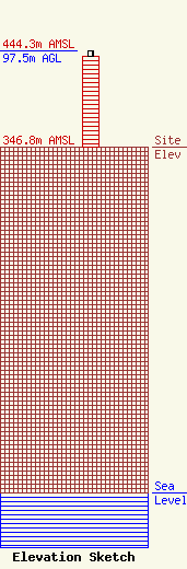
Site Elevation: 346.8 meters (1138 ft) |
| Height of Structure: 91.4 meters (300 feet) |
| Overall Height Above Ground: 97.5 meters (320 feet) |
| Overall Height Above Mean Sea Level: 444.3 meters (1458 feet) |
| Owner Info | Midwest Mobile Radio Service Inc
812 South 10th St
St Joseph, MO 64501
(816) 279-2065
emiller4@ponyexpress.net |
| Info |
