|
|
Antenna Structure Registration 1050418 |
 |
Registration Info | Registration Number: 1050418 |
| File Number: A1303965 |
| FAA Study: 2024-ASW-15855-OE |
| FAA Issue Date: 11/13/2024 |
| Status: Constructed |
| Date Constructed: 08/26/1992 |
| NEPA: N |
Structure Info
| Structure Type: GTOWER |
| Structure Coordinates: 28-54-43.4 N 98-26-29.5 W (NAD 83) |
| Structure Coordinates: 28-54-42.5 N 98-26-28.4 W (Converted to NAD 27) |
| Structure Address: 3921 Us 281 (280310) |
| Structure City: Pleasanton, TX |
| Structure County: Atascosa County |
| Painting & Lighting Info |
FAA Circular #: 70/7460-1K |
FAA Chapters: 4, 8, 12 |
Remarks: PRIOR STUDY 2006-ASW-7553-OE |
Remarks: OM&L to remain the same as prior study = A MED-DUAL SYSTEM |
Remarks: PRIOR STUDY 2006-ASW-7553-OE |
Remarks: OM&L to remain the same as prior study = A MED-DUAL SYSTEM |
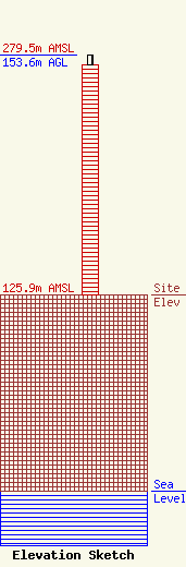
| Elevation Info |
Site Elevation: 125.9 meters (413 ft) |
| Height of Structure: 147.2 meters (483 feet) |
| Overall Height Above Ground: 153.6 meters (504 feet) |
| Overall Height Above Mean Sea Level: 279.5 meters (917 feet) |
| Owner Info | American Towers LLC
10 Presidential Way
Woburn, MA 01801
(781) 926-4500
faa-fcc@americantower.com |
| Contact Info | American Towers LLC
10 Presidential Way
Woburn, MA 01801
(781) 926-4500
faa-fcc@americantower.com |
