|
|
Antenna Structure Registration 1033564 |
 |
Registration Info | Registration Number: 1033564 |
| File Number: A0039828 |
| FAA Study: 82-ANM-068-OE |
| FAA Issue Date: 03/11/1982 |
| Status: Constructed |
| Date Constructed: 06/20/1982 |
| NEPA: N |
Structure Info
| Structure Type: TOWER |
| Structure Coordinates: 46-33-15.0 N 123-3-30.0 W (NAD 83) |
| Structure Coordinates: 46-33-15.6 N 123-03-25.5 W (Converted to NAD 27) |
| Structure Address: On Crego Hill 12 Mi S |
| Structure City: Centralia Chehalis, WA |
| Structure County: Lewis County |
| Painting & Lighting Info |
FAA Circular #: 70/7460-1F |
FAA Chapters: 3, 5, 9 |
Remarks: RED LIGHTS/PAINT |
| Elevation Info |
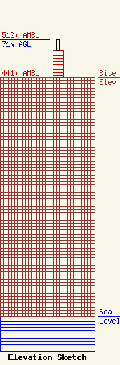
Site Elevation: 441 meters (1447 ft) |
| Height of Structure: 51 meters (167 feet) |
| Overall Height Above Ground: 71 meters (233 feet) |
| Overall Height Above Mean Sea Level: 512 meters (1680 feet) |
| Owner Info | CENTRALIA SCHOOL DISTRICT
2320 BORST AVE
610
CENTRALIA, WA 98531-0610
(360) 330-7644
|
