|
|
Antenna Structure Registration 1064353 |
 |
Registration Info | Registration Number: 1064353 |
| File Number: A1003985 |
| FAA Study: 2016-ACE-822-OE |
| FAA Issue Date: 03/17/2016 |
| Status: Constructed |
| Date Constructed: 01/01/1992 |
| NEPA: N |
Structure Info
| Structure Type: GTOWER |
| Structure Coordinates: 40-12-21.2 N 98-56-43.5 W (NAD 83) |
| Structure Coordinates: 40-12-21.2 N 98-56-42.2 W (Converted to NAD 27) |
| Structure Address: 1326 "o" Road (ne20061-a) |
| Structure City: Franklin, NE |
| Structure County: Franklin County |
| Painting & Lighting Info |
FAA Circular #: 70/7460-1L |
FAA Chapters: 4, 8, 12 |
| Elevation Info |
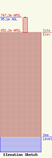
Site Elevation: 652.2 meters (2140 ft) |
| Height of Structure: 93.9 meters (308 feet) |
| Overall Height Above Ground: 95.1 meters (312 feet) |
| Overall Height Above Mean Sea Level: 747.3 meters (2452 feet) |
| Owner Info | SBA Steel LLC
8051 Congress Avenue
Boca Raton, FL 33487
(561) 995-7670
ERoach@sbasite.com |
| Contact Info | SBA Steel LLC
8051 Congress Avenue
Boca Raton, FL 33487
Edward Roach
(561) 995-7670
ERoach@sbasite.com |
