|
|
Antenna Structure Registration 1023203 |
 |
Registration Info | Registration Number: 1023203 |
| File Number: A0027681 |
| FAA Study: 91-ANM-0499-OE |
| FAA Issue Date: 08/15/1991 |
| Status: Constructed |
| Date Constructed: 01/01/1991 |
| NEPA: N |
Structure Info
| Structure Type: TOWER |
| Structure Coordinates: 40-1-28.0 N 102-40-0.0 W (NAD 83) |
| Structure Coordinates: 40-01-28.0 N 102-39-58.3 W (Converted to NAD 27) |
| Structure Address: 6 Mi S, 2 E, 1/2 S And 3/4 E Of Hwy 59 & 34 |
| Structure City: Yuma, CO |
| Structure County: Yuma County |
| Painting & Lighting Info |
FAA Circular #: 70/7460-1H |
FAA Chapters: 3, 4, 5, 13 |
| Elevation Info |
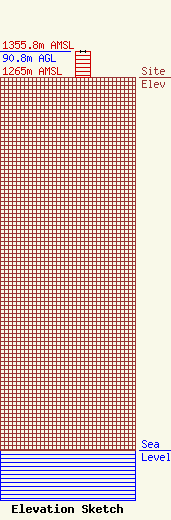
Site Elevation: 1265 meters (4150 ft) |
| Height of Structure: 90.8 meters (298 feet) |
| Overall Height Above Ground: 90.8 meters (298 feet) |
| Overall Height Above Mean Sea Level: 1355.8 meters (4448 feet) |
| Owner Info | DIECKMAN, DONALD E DBA = COLLINS COMMUNICATIONS
101 N LINK LANE #1
FORT COLLINS, CO 80524
(970) 493-6356
|
