|
|
Antenna Structure Registration 1037564 |
 |
Registration Info | Registration Number: 1037564 |
| File Number: A0933422 |
| FAA Study: 2014-ANM-213-OE |
| FAA Issue Date: 02/05/2014 |
| Status: Constructed |
| Date Constructed: 01/27/2015 |
Structure Info
| Structure Type: GTOWER |
| Structure Coordinates: 39-22-34.3 N 103-41-42.9 W (NAD 83) |
| Structure Coordinates: 39-22-34.3 N 103-41-41.1 W (Converted to NAD 27) |
| Structure Address: 19919 County Road 3p (#9013) |
| Structure City: Limon, CO |
| Structure County: Lincoln County |
| Painting & Lighting Info |
FAA Circular #: 70/7460-1K |
FAA Chapters: 4, 8, 12 |
Remarks: PRIOR STUDY 2007-ANM-3901-OE |
| Elevation Info |
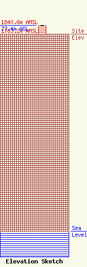
Site Elevation: 1763.2 meters (5785 ft) |
| Height of Structure: 75.9 meters (249 feet) |
| Overall Height Above Ground: 77.4 meters (254 feet) |
| Overall Height Above Mean Sea Level: 1840.6 meters (6039 feet) |
| Owner Info | American Towers LLC
10 Presidential Way
Woburn, MA 01801
(678) 564-3236
faa-fcc@americantower.com |
| Contact Info | American Towers, LLC.
10 Presidential Way
Woburn, MA 01801
(678) 564-3236
faa-fcc@americantower.com |
