|
|
Antenna Structure Registration 1053974 |
 |
Registration Info | Registration Number: 1053974 |
| File Number: A1181721 |
| FAA Study: 2018-ASW-12027-OE |
| FAA Issue Date: 02/18/2020 |
| Status: Constructed |
| Date Constructed: 01/01/1981 |
| NEPA: N |
Structure Info
| Structure Type: GTOWER |
| Structure Coordinates: 32-2-54.6 N 102-18-5.6 W (NAD 83) |
| Structure Coordinates: 32-02-54.2 N 102-18-04.1 W (Converted to NAD 27) |
| Structure Address: 16841 Derby Ave |
| Structure City: Gardendale, TX |
| Structure County: Ector County |
| Painting & Lighting Info |
FAA Circular #: 70/7460-1L |
FAA Chapters: 4, 8, 12 |
Remarks: OM&L to remain the same as original issue date 08/16/2018 = A MED-DUAL SYSTEM |
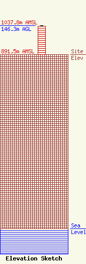
| Elevation Info |
Site Elevation: 891.5 meters (2925 ft) |
| Height of Structure: 143.9 meters (472 feet) |
| Overall Height Above Ground: 146.3 meters (480 feet) |
| Overall Height Above Mean Sea Level: 1037.8 meters (3405 feet) |
| Owner Info | American Towers LLC
10 Presidential Way
Woburn, MA 01801
(781) 926-4500
faa-fcc@americantower.com |
| Contact Info | American Towers LLC
10 Presidential Way
Woburn, MA 01801
(781) 926-4500
faa-fcc@americantower.com |
