|
|
Antenna Structure Registration 1235627 |
 |
Registration Info | Registration Number: 1235627 |
| File Number: A0354498 |
| FAA Study: 99-ANM-1845-OE |
| FAA Issue Date: 02/28/2000 |
| Status: Constructed |
| Date Constructed: 10/01/1982 |
| FAA EMI: N |
| NEPA: N |
Structure Info
| Structure Type: TOWER |
| Structure Coordinates: 44-3-43.6 N 116-54-25.6 W (NAD 83) |
| Structure Coordinates: 44-03-44.0 N 116-54-22.0 W (Converted to NAD 27) |
| Structure Address: S E Of Intersection Of Iowa Ave And State Hwy 52 |
| Structure City: Payette, ID |
| Structure County: Payette County |
| Painting & Lighting Info |
FCC Paragraph(s): 1, 3, 4, 13, 21 |
Remarks: PRIOR FAA 99-ANM-0221-OE CONTINUE OM&L PAINT/RED LIGHTS |
| Elevation Info |
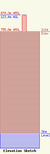
Site Elevation: 755.9 meters (2480 ft) |
| Height of Structure: 122.5 meters (402 feet) |
| Overall Height Above Ground: 123.4 meters (405 feet) |
| Overall Height Above Mean Sea Level: 879.3 meters (2885 feet) |
| Owner Info | SUTRO CORPORATION
1826
BOISE, ID 83701
(208) 867-9971
|
