|
|
Antenna Structure Registration 1249910 |
 |
Registration Info | Registration Number: 1249910 |
| File Number: A1296658 |
| FAA Study: 2021-AGL-24216-OE |
| FAA Issue Date: 09/09/2021 |
| Status: Constructed |
| Date Constructed: 12/01/2009 |
| NEPA: N |
Structure Info
| Structure Type: GTOWER |
| Structure Coordinates: 48-56-9.9 N 99-56-52.4 W (NAD 83) |
| Structure Coordinates: 48-56-09.9 N 99-56-50.9 W (Converted to NAD 27) |
| Structure Address: One Mile South Of Highway 43 |
| Structure City: St. John, ND |
| Structure County: Rolette County |
| Painting & Lighting Info |
FAA Circular #: 70/7460-1M |
FAA Chapters: 4, 6, 15 |
Remarks: PRIOR STUDY 2009-AGL-1649-OE |
| Elevation Info |
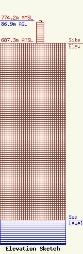
Site Elevation: 687.3 meters (2255 ft) |
| Height of Structure: 80.8 meters (265 feet) |
| Overall Height Above Ground: 86.9 meters (285 feet) |
| Overall Height Above Mean Sea Level: 774.2 meters (2540 feet) |
| Owner Info | United Telephone Mutual Aid Corporation
411 7th Avenue
729
Langdon, ND 58249-0729
(701) 256-5156
ajhensel@corp.utma.com |
| Contact Info | Lukas, LaFuria, Lantor & Sachs, LLP
8350 Broad Street
Tysons, VA 22102
Todd Slamowitz
(703) 584-8673
tslamowitz@fcclaw.com |
