|
|
Antenna Structure Registration 1246670 |
 |
Registration Info | Registration Number: 1246670 |
| File Number: A1069218 |
| FAA Study: 2017-ACE-1117-OE |
| FAA Issue Date: 03/16/2017 |
| Status: Constructed |
| Date Constructed: 02/01/2005 |
| NEPA: N |
Structure Info
| Structure Type: GTOWER |
| Structure Coordinates: 39-44-3.5 N 94-47-23.9 W (NAD 83) |
| Structure Coordinates: 39-44-03.5 N 94-47-23.0 W (Converted to NAD 27) |
| Structure Address: 3011 S. 42nd Street |
| Structure City: St. Joseph, MO |
| Structure County: Buchanan County |
| Painting & Lighting Info |
FAA Circular #: 70/7460-1K |
FAA Chapters: 4, 8, 12 |
Remarks: OM&L to remain the same as prior study = A MED-DUAL SYSTEM |
Remarks: PRIOR STUDY 2004-ACE-2340-OE |
Remarks: OM&L to remain the same as prior study = A MED-DUAL SYSTEM |
Remarks: PRIOR STUDY 2004-ACE-2340-OE |
| Elevation Info |
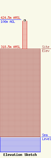
Site Elevation: 318.5 meters (1045 ft) |
| Height of Structure: 100.5 meters (330 feet) |
| Overall Height Above Ground: 106 meters (348 feet) |
| Overall Height Above Mean Sea Level: 424.5 meters (1393 feet) |
| Owner Info | Midwest Mobile Radio Service
812 S. 10th Street
St. Joseph, MO 64501
(816) 279-2065
erniem@mw-radio.com |
| Contact Info | Midwest Mobile Radio Service, Inc.
812 S. 10th Street
St. Joseph, MO 64501
Ernest Miller
(816) 279-2065
erniem@mw-radio.com |
