|
|
Antenna Structure Registration 1228187 |
 |
Registration Info | Registration Number: 1228187 |
| File Number: A0656051 |
| FAA Study: 01-ASW-2036-OE |
| FAA Issue Date: 06/26/2001 |
| Status: Constructed |
| Date Constructed: 09/12/2002 |
| FAA EMI: N |
| NEPA: N |
Structure Info
| Structure Type: TOWER |
| Structure Coordinates: 29-17-24.9 N 98-15-21.0 W (NAD 83) |
| Structure Coordinates: 29-17-24.0 N 98-15-20.0 W (Converted to NAD 27) |
| Structure Address: Ene Intersection Of Sr 1604 And 181 |
| Structure City: Elmendorf, TX |
| Structure County: Wilson County |
| Painting & Lighting Info |
FAA Circular #: 70/7460-1K |
FAA Chapters: 4, 7, 12 |
Remarks: PRIOR STUDY 00-ASW-2214-OE |
Remarks: Removed expiration and final dates from determination. Scenario 2./jjs/case#635066 |
Remarks: PRIOR STUDY 00-ASW-2214-OE |
| Elevation Info |
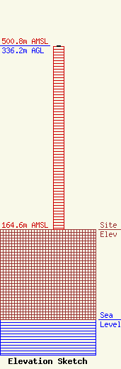
Site Elevation: 164.6 meters (540 ft) |
| Height of Structure: 335.2 meters (1100 feet) |
| Overall Height Above Ground: 336.2 meters (1103 feet) |
| Overall Height Above Mean Sea Level: 500.8 meters (1643 feet) |
| Owner Info | San Antonio Community Educational TV, Inc.
691246
San Antonio, TX 78269
(210) 479-0123
bmiller@tbn.org |
| Contact Info | Warren B. Miller, Technical Consultant
2442 Michelle Dr.
Tustin, CA 92780
Warren Miller
(714) 665-2145
bmiller@tbn.org |
