|
|
Antenna Structure Registration 1049450 |
 |
Registration Info | Registration Number: 1049450 |
| File Number: A1037099 |
| FAA Study: 2011-ASW-6219-OE |
| FAA Issue Date: 11/01/2011 |
| Status: Constructed |
| Date Constructed: 01/01/1987 |
| FAA EMI: N |
| NEPA: N |
Structure Info
|
| Structure Coordinates: 29-37-23.8 N 95-33-8.0 W (NAD 83) |
| Structure Coordinates: 29-37-23.0 N 95-33-07.2 W (Converted to NAD 27) |
| Structure Address: 13627 2/3 Stafford Rd. (004267) |
| Structure City: Stafford, TX |
| Structure County: Fort Bend County |
| Painting & Lighting Info |
FCC Paragraph(s): 1, 3, 4, 13, 21 |
Remarks: Continue As Is OM&L = PAINT/RED LIGHTS |
Remarks: PRIOR STUDY 2005-ASW-4296-OE |
Remarks: Continue As Is OM&L = PAINT/RED LIGHTS |
Remarks: PRIOR STUDY 2005-ASW-4296-OE |
| Elevation Info |
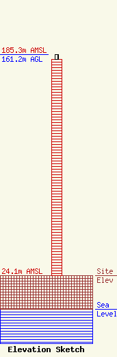
Site Elevation: 24.1 meters (79 ft) |
| Height of Structure: 157.9 meters (518 feet) |
| Overall Height Above Ground: 161.2 meters (529 feet) |
| Overall Height Above Mean Sea Level: 185.3 meters (608 feet) |
| Owner Info | American Towers LLC
10 Presidential Way
Woburn, MA 01801
(781) 926-4500
faa-fcc@americantower.com |
| Contact Info | American Towers, LLC
10 Presidential Way
Woburn, MA 01801
(781) 926-4500
faa-fcc@americantower.com |
