|
|
Antenna Structure Registration 1240500 |
 |
Registration Info | Registration Number: 1240500 |
| File Number: A0345737 |
| FAA Study: 2003-ANM-1800-OE |
| FAA Issue Date: 09/29/2003 |
| Status: Granted |
| NEPA: N |
Structure Info
| Structure Type: POLE |
| Structure Coordinates: 47-22-50.5 N 120-17-19.3 W (NAD 83) |
| Structure Coordinates: 47-22-51.0 N 120-17-15.0 W (Converted to NAD 27) |
| Structure Address: Wenatchee Heights |
| Structure City: Wenatchee, WA |
| Structure County: Chelan County |
| Painting & Lighting Info |
FAA Circular #: |
FAA Chapters: NONE |
Remarks: Removed expiration date from determination. Scenario 1./jjs/case#635066 |
| Elevation Info |
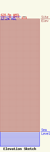
Site Elevation: 616.3 meters (2022 ft) |
| Height of Structure: 12.2 meters (40 feet) |
| Overall Height Above Ground: 12.2 meters (40 feet) |
| Overall Height Above Mean Sea Level: 628.5 meters (2062 feet) |
| Owner Info | BUTTERFIELD BROADCASTING CORP.
706 BUTTERFIELD RD
YAKIMA, WA 98901
(509) 457-1000
|
| Contact Info | HATFIELD & DAWSON CONSULTING ENGINEERS
9500 GREENWOOD AVE N
SEATTLE, WA 98103
ERIK SWANSON
(206) 783-9151
ESWANSON@HATDAW.COM |
