|
|
Antenna Structure Registration 1282500 |
 |
Registration Info | Registration Number: 1282500 |
| File Number: A0775018 |
| FAA Study: 2011-ANM-3171-OE |
| FAA Issue Date: 01/25/2012 |
| Status: Constructed |
| Date Constructed: 03/30/2012 |
| FAA EMI: N |
| NEPA: N |
Structure Info
| Structure Type: TOWER |
| Structure Coordinates: 46-19-2.7 N 111-25-53.1 W (NAD 83) |
| Structure Coordinates: 46-19-02.9 N 111-25-50.2 W (Converted to NAD 27) |
| Structure Address: 56 Granger Way |
| Structure City: Townsend, MT |
| Structure County: Broadwater County |
| Painting & Lighting Info |
FAA Chapters: NONE |
Remarks: Removed expiration date from determination. Scenario 1./jjs/case#635066 |
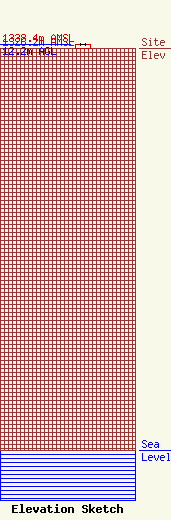
| Elevation Info |
Site Elevation: 1326.2 meters (4351 ft) |
| Height of Structure: 12.2 meters (40 feet) |
| Overall Height Above Ground: 12.2 meters (40 feet) |
| Overall Height Above Mean Sea Level: 1338.4 meters (4391 feet) |
| Owner Info | Montana Internet Corporation
1420
Helena, MT 59624-1420
(406) 443-3347
fwc@mt.net |
| Contact Info | Montana Internet Corporation
1420
Helena, MT 59624-1420
Edward Brooks
(406) 443-3347
brookse@mt.net |
