|
|
Antenna Structure Registration 1279398 |
 |
Registration Info | Registration Number: 1279398 |
| File Number: A1154146 |
| FAA Study: 2011-ANM-722-OE |
| FAA Issue Date: 05/19/2011 |
| Status: Constructed |
| Date Constructed: 10/28/2011 |
| FAA EMI: N |
| NEPA: N |
Structure Info
| Structure Type: TOWER |
| Structure Coordinates: 41-48-43.5 N 111-47-32.8 W (NAD 83) |
| Structure Coordinates: 41-48-43.8 N 111-47-30.0 W (Converted to NAD 27) |
| Structure Address: Nw 1/4, Sec 1, T12n, R1e - Off Of Cr 4400 N |
| Structure City: Hyde Park, UT |
| Structure County: Cache County |
| Painting & Lighting Info |
FAA Chapters: NONE |
| Elevation Info |
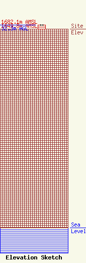
Site Elevation: 1649.8 meters (5413 ft) |
| Height of Structure: 30.5 meters (100 feet) |
| Overall Height Above Ground: 32.3 meters (106 feet) |
| Overall Height Above Mean Sea Level: 1682.1 meters (5519 feet) |
| Owner Info | Cellco Partnership
5055 North Point Pkwy
Alpharetta, GA 30022
(770) 797-1070
Network.Regulatory@verizonwireless.com |
| Contact Info | Cellco Partnership
5055 North Point Pkwy
Alpharetta, GA 30022
Regulatory Manager
(770) 797-1070
Network.Regulatory@verizonwireless.com |
