|
|
Antenna Structure Registration 1217373 |
 |
Registration Info | Registration Number: 1217373 |
| File Number: A0320094 |
| FAA Study: 01-anm-2589-oe |
| FAA Issue Date: 03/13/2002 |
| Status: Constructed |
| Date Constructed: 04/12/1995 |
| FAA EMI: N |
| NEPA: N |
Structure Info
| Structure Type: TOWER |
| Structure Coordinates: 43-29-27.0 N 112-2-58.0 W (NAD 83) |
| Structure Coordinates: 43-29-27.3 N 112-02-55.1 W (Converted to NAD 27) |
| Structure Address: 545 South Utah Circle |
| Structure City: Idaho Falls, ID |
| Structure County: Bonneville County |
| Painting & Lighting Info |
FAA Circular #: 70/7460-1K |
FAA Chapters: 4, 5, 12 |
Remarks: Removed expiration date from determination. Scenario 1./jjs/case#635066 |
Remarks: PRIOR STUDY 00-ANM-0602-OE |
Remarks: Removed expiration date from determination. Scenario 1./jjs/case#635066 |
| Elevation Info |
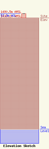
Site Elevation: 1433.2 meters (4702 ft) |
| Height of Structure: 54.9 meters (180 feet) |
| Overall Height Above Ground: 57.3 meters (188 feet) |
| Overall Height Above Mean Sea Level: 1490.5 meters (4890 feet) |
| Owner Info | Teton Communications Inc
545 S Utah Circle
Idaho Falls, ID 83402
(208) 522-0750
|
| Contact Info | Teton Communications Inc
545 S Utah Circle
Idaho Falls, ID 83402
Tony or Rick Hafla
(208) 522-0750
|
