|
|
Antenna Structure Registration 1053112 |
 |
Registration Info | Registration Number: 1053112 |
| File Number: A0497349 |
| FAA Study: 93-ASW-0734-OE |
| FAA Issue Date: 06/24/1993 |
| Status: Dismantled |
| Date Constructed: 01/01/1993 |
| FAA EMI: N |
| NEPA: N |
Structure Info
| Structure Type: BTWR |
| Structure Coordinates: 29-45-31.0 N 95-22-4.0 W (NAD 83) |
| Structure Coordinates: 29-45-30.2 N 95-22-03.2 W (Converted to NAD 27) |
| Structure Address: 1000 Louisiana |
| Structure City: Houston, TX |
| Structure County: Harris County |
| Painting & Lighting Info |
FCC Paragraph(s): 1, 3, 12, 21 |
Remarks: RED LIGHTS/PAINT |
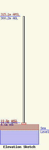
| Elevation Info |
Site Elevation: 14.9 meters (49 ft) |
| Height of Structure: 4.6 meters (15 feet) |
| Overall Height Above Ground: 300.2 meters (985 feet) |
| Overall Height Above Mean Sea Level: 315.1 meters (1034 feet) |
| Owner Info | MCI Communications Services, Inc.
2400 N. Glenville Dr., 71216/107
Richardson, TX 75802
(972) 729-6406
Laura.Birkelbach@mci.com |
| Contact Info | MCI Communications Services, Inc.
2400 N. Glenville Dr., 71216/107
Richardson, TX 75082
Laura Birkelbach
(972) 729-6406
Laura.Birkelbach@mci.com |
