|
|
Antenna Structure Registration 1203170 |
 |
Registration Info | Registration Number: 1203170 |
| File Number: A1245428 |
| FAA Study: 86-ACE-0668-OE |
| FAA Issue Date: 01/29/1987 |
| Status: Constructed |
| Date Constructed: 05/12/1987 |
| FAA EMI: N |
| NEPA: N |
Structure Info
| Structure Type: TOWER |
| Structure Coordinates: 37-34-32.0 N 101-19-11.6 W (NAD 83) |
| Structure Coordinates: 37-34-31.9 N 101-19-10.0 W (Converted to NAD 27) |
| Structure Address: 2 Mile E On Hwy 160-1/2 Mile N-1/4 Mile E-200yards S |
| Structure City: Ulysses, KS |
| Structure County: Grant County |
| Painting & Lighting Info |
FCC Paragraph(s): 1, 3, 4, 13, 21 |
Remarks: RED LIGHTS/PAINT |
| Elevation Info |
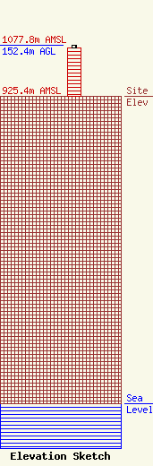
Site Elevation: 925.4 meters (3036 ft) |
| Height of Structure: 146.3 meters (480 feet) |
| Overall Height Above Ground: 152.4 meters (500 feet) |
| Overall Height Above Mean Sea Level: 1077.8 meters (3536 feet) |
| Owner Info | Merit Energy Company
13727 Noel Road Suite 500
Dallas, TX 75240
(620) 629-4219
Michael.Aichele@meritenergy.com |
| Contact Info | Lockard & White, Inc.
3001 Earl Rudder Fwy, Suite 100
College Station, TX 77845
License Administrator
(281) 586-5700
licensing@lockardandwhite.com |
