|
|
Antenna Structure Registration 1007984 |
 |
Registration Info | Registration Number: 1007984 |
| File Number: A0816134 |
| FAA Study: 2012-ANM-804-OE |
| FAA Issue Date: 04/20/2012 |
| Status: Constructed |
| Date Constructed: 06/18/1989 |
| FAA EMI: N |
| NEPA: N |
Structure Info
| Structure Type: TOWER |
| Structure Coordinates: 43-27-42.2 N 110-45-15.1 W (NAD 83) |
| Structure Coordinates: 43-27-42.5 N 110-45-12.4 W (Converted to NAD 27) |
| Structure Address: .8 Mi S (275201) |
| Structure City: Jackson, WY |
| Structure County: Teton County |
| Painting & Lighting Info |
FAA Chapters: NONE |
Remarks: PRIOR STUDY 1992-ANM-174-OE |
| Elevation Info |
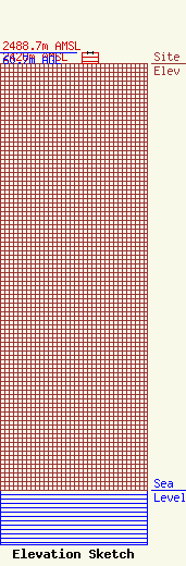
Site Elevation: 2428 meters (7966 ft) |
| Height of Structure: 59.1 meters (194 feet) |
| Overall Height Above Ground: 60.7 meters (199 feet) |
| Overall Height Above Mean Sea Level: 2488.7 meters (8165 feet) |
| Owner Info | American Towers LLC
10 Presidential Way
Woburn, MA 01801
(678) 564-3236
faa-fcc@americantower.com |
| Contact Info | American Towers, LLC.
10 Presidential Way
Woburn, MA 01801
(678) 564-3236
faa-fcc@americantower.com |
