|
|
Antenna Structure Registration 1024854 |
 |
Registration Info | Registration Number: 1024854 |
| File Number: A0282211 |
| Status: Constructed |
| Date Constructed: 01/01/1960 |
| FAA EMI: N |
| NEPA: N |
Structure Info
| Structure Type: TOWER |
| Structure Coordinates: 48-6-59.0 N 96-11-33.0 W (NAD 83) |
| Structure Coordinates: 48-06-59.1 N 96-11-31.9 W (Converted to NAD 27) |
| Structure Address: Sw 1/4 Of Nw 1/4 Sec 33 T154n R43w |
| Structure City: Thief River Falls, MN |
| Structure County: Pennington County |
| Painting & Lighting Info |
FCC Paragraph(s): 1, 3, 11, 21 |
| Elevation Info |
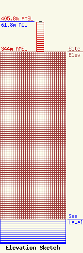
Site Elevation: 344 meters (1129 ft) |
| Height of Structure: 60.9 meters (200 feet) |
| Overall Height Above Ground: 61.8 meters (203 feet) |
| Overall Height Above Mean Sea Level: 405.8 meters (1331 feet) |
| Owner Info | Wikstrom Telephone Company
212 S Main St
217
Karlstad, MN 56732
(218) 436-2121
angiea@wiktel.com |
| Info |
